Thursday 26 November 2009

Loriga - Serra da Estrela

In contrast to today, Monday and Tuesday were beautiful. On Tuesday we went out geocaching in the Serra da Estrela to the town of Loriga. First we visited the turismo and managed to get loads of leaflets, some detailing walks in the area. On closer inspection some of these are circular and some are shorter linear versions tagged on to the main trails that run through the Serra da Estrela. Another booklet the lady in the centre gave us was outlining walking (and separate car) routes of the glacier valleys. These are all linear though so extra forward planning required. The lady in the tourist information centre spoke excellent English.

Next we grabbed a coffee, treated ourselves to a bottle of organic Medronho Brandy (and as it cost 22.90 euros it will be a treat!). We also bought some bread rolls and "Bon Bons" from a local bakery. The Bon Bons were like little doughnuts with a what might have been a custard filling.

Then we made our way up to where we knew there was a river beach (praia fluvial) at Loriga. We were not disappointed. The council have worked hard to make this a great place for all the family to visit and enjoy the river in it's wonderful surroundings. Today we were the only ones there and enjoyed our packed lunch in harmony with nature.


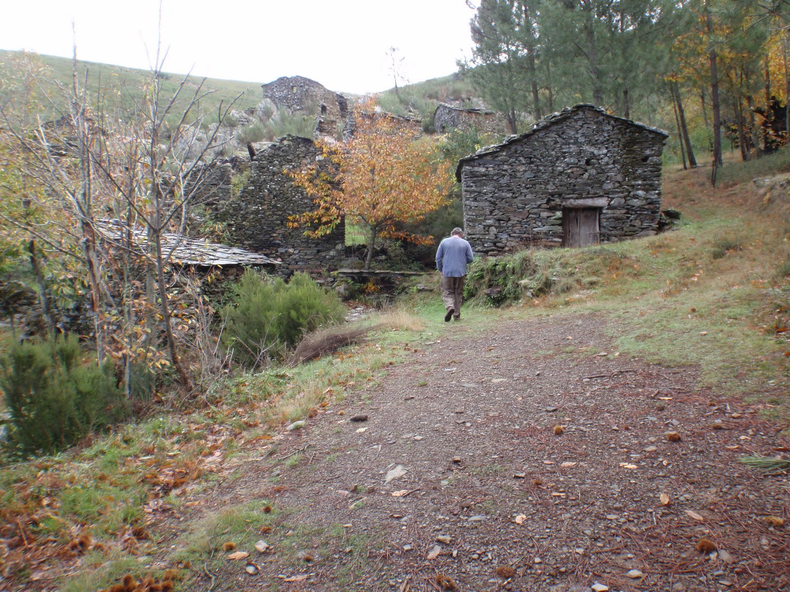
We then set off for the nearest geocache, ie Casa dos Ingleses (house of the English) or also known as "Penedo de Alvoco". It seems that the house was originally inhabited by locals (one of the inhabitants was born 1825 and died in 1900) but then the area was inhabited by English who were mining for metal in the area. One of these (by the name of James) died in November 1911 and was buried in the local cemetery. (In 1944 six English aviators were also buried in the same cemetery after crashing in the mountains).

Loriga info: It was an English military airplane; Hudson Aircraft, that had that day left Gibraltar for the United kingdom, carrying the following occupants: Captain-Robert Tavener HILDICK; Lieutenant-John BARBOUR; Lieutenant-Daniel De Waal WALTERS; Lieutenant-John Patie THOM; 1.Cabo-Jack Learoyd WALKER; 1.Cabo Henry Ernest HEDGES.

The Civil Register of Seia, registers the six deaths as having happened on 22 February of 1944. The assumption is that the plane came down in fog.

We returned to the village of Loriga and wandered along to the Roman bridge. But as it was getting late in the day we decided that further exploration (and other geocaches) would need to wait for another day.

We returned home to find a big bag of homegrown potatoes on the porch from our neighbours (recompense for the goats eating all our veggies). On Sunday they had given us one of their goat cheeses and asked if we wanted them to pay for the damaged crops. We would not accept any money, it wouldn't be right. Yesterday there were further gifts of cabbages and turnips, freshly harvested.

Wednesday 25 November 2009

Weather

We think we have the "weather" sussed out now. First we check what the local forecast is (ie lower down where we are) and then we also look at the webcam for Manteigas that is tucked snugly in the middle of the mountains. If the overall forecast is reasonable and the picture of Manteigas is clear then we go for it. We could go out in most weathers but fine days are still plentiful at this time of year so we prefer to pick and choose. There's not much point travelling up the winding roads of the mountains for a view as far as the car bonnet. The other thing we have noticed is that the weather forecast predictions change almost daily. You can't rely on looking at more than the immediate day ahead.

Today, Thursday, as I write this, the webcam for Mantegias reveals mist and fog up in the mountains. The local forecast is pretty miserable too, 50% chance of precipitation and cloudy. We were intending to visit Piódão and Chas d'Egua but they are in the mountains as well, so that's not really feasible today. See webcam image of Manteigas below, taken at 08.46 this morning.


And Manteigas webcam image approximately one hour later...

Friday 20 November 2009

Caminho do Xisto da Benfeita - Way of the Shale of the Benfeita

Friday was a perfect day for a walk. Not too hot (forecast max 14 degrees celsius) no rain, and clear. We set off from Benfeita, walked uphill for about 3 miles to a small mountain village called Sardal, and then it was mostly downhill past Fraga da Pena (waterfalls and picnic area) through Pardieros (another small mountain village) - stopping for a coffee at a local bar - and then the final leg down through a valley back to Benfeita. The walk is one of the aldeias walks, and is quite well signposted, though a few times we couldn't see the markers and plumped for what we hoped was the right way. Fortunately we were right most of the time. We did have the gpx track provided and used that to confirm our passage using our new gps. We had also calibrated in Google Earth the basic map of this walk (NB: at the time of writing the map is only obtainable at the start of the walk itself - we'd been through Benfeita a few times and took a photo of the map board). One of the real problems we have been having is there are no detailed maps apart from military maps - the price of the maps is not cheap). There are plenty of walks, it seems, but you seem to have to pay for a guide to take you out to know where most of them are. The walk we did yesterday would have cost us 25 euros each, and that didn't include lunch or travelling to the starting point.


The walk is about 10km in total, and takes you through current and abandoned agricultural landscape, past ruined schist villages, countless waterfalls, and woodland. At a leisurely pace, stopping for taking photos and having a snack, it took us about 5 hours. Apart from when we stopped for a coffee, the only people we saw were two Portugese villagers harvesting olives.

It felt such a privilege to be able to wander this area freely. It was like stepping into a secret garden on a mega scale. Almost every turn had another nook, cranny, wonderful view, gushing stream or waterfall. The floor was strewn with many different varieties of mushrooms, fallen chestnuts, walnuts, and fruit. Sometimes the path was vivid red with the fallen medronho berries from the Strawberry Tree.

3 December 2009 - Additional Note: This site has a little more information about the Benfeita walk and some information about Piodao.

Thursday 19 November 2009

Colcurinho

Yesterday we set off to do a geocache multi-cache with our new gps unit. With a new unit there are a few things you need to do, first of all it has travelled from the UK so it needs to find where it is, and then Jon had to calibrate the compass by holding the unit level, and turn round slowly in the same direction twice. No, it's not 1 April. It worked.

The multi-cache started at an amazing ruined schist village called Colcurinho. We explored the village and found the clues to the next stage. At the side of the village we noticed a footpath sign (noted to explore on another day).


Part two of the multi took us to a really pretty village called Santuário de Nossa Senhora das Preces. To enter the village you drive through gates, which feels a bit like you are trespassing. It sort of reminded us of Portmeirion, only you didn't pay to go in. We had a really lovely cup of coffee (cafe meio leite) at the cafe kiosk in the main square, 55 cents a cup. We found our cache clue which would take us to our final destination, but before we set off we visited the Botanical Garden.

The third and final part of the cache took us up, up, up and up to the top of Monte Colcurinho. On the top of the mountain is a chapel called Capela da Nossa Senhora das Necessidade. This place also has toilets, and a bar area. It was all locked up but we gather they have festas up here. The panoramic views were fantastic.

The gps performed very well, though we want to try and conserve the power a bit more to use less batteries. There are other things we want to try out with the gps, uploading existing gpx tracks for walks, and uploading the maps we aligned in Google Earth to see how accurate they are.

Today we are off to Arganil (Thursday is market day) to visit the tourist information centre mainly. We want to try and find information about the Centro Interpretativo de Chãs d´Égua, Arganil (Arte Rupestre near Piodao). We found out, when we were trying to find the walks near Colcurinho, that there are ancient cart tracks and spirals and the centre at Chas de Egua is dedicated to these.

Wednesday 18 November 2009

Parcels

We have received various parcels this week. For parcels too large to fit into our post box at the top of the track, the postman leaves a card telling us to go to the post office at Galizes to collect it. Galizes is about a 10 minute drive away. Jon showed his passport as proof of identification. Very straightforward.

A parcel arrived from Barry and Lorraine, who had kindly gathered together about a dozen films for us to watch. We don't have a DVD player but they play fine on the laptop, and we have some speakers plugged in as well and it works a treat. Cuddling up on the sofa to watch a film is something of an event for us and feels special.

Another parcel arrived from Viv and Michael, with a Christmas card and wrapped presents. The card has been opened but the presents will be saved for Christmas morning.

We had our main Christmas present (to each other) early, and it arrived yesterday by Fedex. The chap from Fedex spoke only Portugese, and he was asking for Jon to sign for the package. But Jon was in the bath. So I said "banho" and did an impression of Jon scrubbing himself off in the bath. I think the chappie knew what I meant as he let me sign for the package and beat a rather hasty retreat.

Our present to each other this year is a new GPS. We broke the old Garmin Legend the other day, and though Jon rigged the pocket computer/satnav to act as a handheld GPS, it just wasn't the same sitting in the palm of your hand. Our Garmin Legend owed us nothing and, because we used it so much, we decided to treat ourselves to a new model. Our new GPS is a Garmin Oregon 300 and, by all accounts, it's fab.

Mapping (to Ordinance Survey standards) is something we are having a problem with over here. Jon recently discovered that with our new GPS we should be able to upload maps to it that we have calibrated in Google Earth. It's all very experimental at the moment, but if it works it will be a boon.

This morning there is a mist hanging over the valley, but it's early at the moment (0800) so hopefully the sun will burn that off by mid morning. Yesterday was warm and sunny, but the previous two days were wet but mild.

We also experienced our second thunderstorm. It came over us so fast we barely had time to unplug everything, including the telephone, when there was an enormous clap of thunder right overhead and the electricity went off.

This time we were armed with torches. Twig was inside safe and sound, though obviously terrified. Jon sorted the electrics, it was just a trip of the switches. After that the storm moved off very quickly, thank goodness.

Saturday 14 November 2009

Olive Harvest

The past few weeks has been olive harvesting time.

Some folk may take their harvest to a local village where the olives will be pressed en masse. Or if you have enough to do a single press that is another option if for example yours are organic and do not get mixed with the communal lot that may not be organic. An olive mill is called a Lagar de Azeite.

For those olives pressed communally the harvest you take in is weighed beforehand and then you get a proportion of the olive oil that is produced. Apparently the mills only open for a limited amount of time each year so it's quite important to get in early.

The Expats Portugal forum has more information.

Pruning also takes place at this time of year. Pruning olive trees is something of an acquired skill apparently.

The Mountain Village of Balocas


Yesterday we had a lovely day out. We did two geocaches, that took us up into the mountain village of Balocas in the Serra do Acor. Up in the mountains it felt a bit like a summer's day in the Lake District, ie damp, misty, but with astoundingly beautiful scenery. We had left glorious sunshine back down in the valley.

The mist was slowly beginning to clear as the day went on and the views improved. We snacked at the picnic site at Balocas that had wonderful views of the valley below.


The first cache was to a waterfall that was quite a way off the beaten path. The second cache took us up to a building that the forestry commission use as a look out point for forest fires etc.

As usual we had the place entirely to ourselves.

When we arrived home we found, to our dismay, the goats and sheep had been in the garden again and this time they left us with very little. The herd ate all the lettuce, cabbages, broccoli, most of the pepper plants and even the tomatoes. We are quite annoyed about it. However, because we don't own the place we will not be spending money on goat-proofing the garden, so for this trip out here there will be no more vegetable growing. When we come to buy a place we will make sure there are no goats for neighbours or there will probably be, almost definitely, murder committed.

They left the beetroot though! Maybe so they can come back for it another day!

Just found a site and here are some ideas on how to cook goat: succulent chanfana (goat stew in wine sauce) or the equally appreciated maranhos (pluck of goat with rice), roast kid...

Wednesday 11 November 2009

Sra Da Piedade - Fairytale Place


Today and yesterday the weather has perked up a bit, though it's still pretty overcast. Yesterday we had a trip to Lousa, which takes just over an hour. The plan was to find the information centre, get maps and guides for the walks that we have seen on the Lousa tourist information site and do two geocaches.

Lousa is quite a large place though not too scary to drive around. We parked easily enough for free. Tuesday is supposed to be a market day, as well as Saturday, but there was no market that we could see and we arrived at 11am.

We wandered the town, looking for the information centre, and marvelled at some of the very old beautiful buildings. But after a while we still couldn't find the information centre. The girl on the reception in the library gave us a map of the town and pointed us in the right direction. Lots of times when you say obrigada, thanking them for their help, they seem embarrassed and say Nao, nada (no, it's nothing), but it is to us!

So we wandered further afield and found the information centre tucked on the outskirts of town (handy!) and looked around the eco museum. We were the only people there. The chap in the info centre spoke very good English, but when we asked for walking maps, guides etc, he couldn't really help us that much. He did give us some leaflets and a basic map, but not really what we needed.

We went back to the car and set off up into the mountains to do our geocaches. Our printer that we brought is currently out of ink (waiting for an order from UK to arrive). Therefore, we were struggling a little to manage without the full geocache information. The parking co-ordinates kept depositing us at the viewpoint (miradouro) above the village we were trying to reach by road. Our satnav was telling us that it had arrived at its destination. What is actually the case, and we have had this twice now, is that you are at the co-ordinates but not at the right altitude. Looking down into the valley below we could see roads to Sra Da Piedade, and that was indeed where we were supposed to park, but we didn't have good enough maps showing us how to reach it.

Still, we were both up for a walk and had sturdy footwear on, so we ventured down a path at the side of the viewpoint, past fallen trees and all. We explored the castle and then set off to find the cache. But we went the wrong way, or, tried to go the hard way! After fording a stream, and then trying to climb slimy rocks at the side of the waterfalls (all in a day's outing for us usually), we realised that we would have to go back across the waterfalls further up. So back down the waterfall, over the stream, then back up to the castle to find the way to the mountain shrine.

To say this place is beautiful is an understatement. It's like being in a fairytale. We had the place to ourselves, but in summer this is probably bursting at the seams with people.


Hot and exhausted from our exploring of Lousa and the village, and knowing we have to climb the hill back to the car, we decided against the second geocache that would involve at least another hour and half walk.

On our way back home we stopped off at Arganil and ventured into the information centre there. We asked the girl, who spoke excellent English, for walking maps and guides in the locality. Again, she could not really help us, though the council is putting walks in place there is no supporting literature at this time. Maybe next year we will have more luck.

Saturday 7 November 2009

Patties

We bought two empadinhas today from Intermarche (1.10 euros each). We wondered if this was what we know fondly as a pasty. "Empadinha" isn't in our Portugese dictionary, and the nearest we could find to the word pasty is pie (or empadao).

Apparently Brazilians have a snack known as an empada or empadinha (little empada).

Anyway, they were delicious and the outer case was not pastry, or bread either, so we would probably describe them as a "patty".

We also did two geocaches while we were out. The one was in a village called Esculca (pron Shkulka) and this gave us fabulous views from a viewpoint (miradoura). We travelled further up the mountain to the Voo Livre (Flight Free), where paragliders launch themselves off the mountain top. On a clear day the views would be fabulous. Even on a dark miserable day today the views were pretty impressive.

The second cache was at a small chapel with ornate stonework.

Roasting Yer Nuts

The past two days we lit the Rayburn and Jon is becoming more accomplished in the task of lighting the fire and getting it to heat the house. Though, it has to be said, he's becoming a bit too adept! To say we were warm is an understatement. Even the cat needed to get out into fresh air as we were all sweating buckets! The extra blankets on the bed were certainly not required, in fact we opened the windows to let some cool air in. The temperature gauge on the Rayburn goes up to 300 degrees Celsius (max) - not sure what happens once it goes above that!

Some of the logs are mimosa and these (being dry and seasoned) burn very well. Jon has found that three or four of the logs will keep the Rayburn going all day, rather than the split logs, that burn faster. The logs kept whole, also seem to generate more heat once they have caught.

Jon made a delicious wintery chestnut soup, though it was a fiddly job shelling and skinning the chestnuts.

I made a bean bake and allowed it to slow cook in the Rayburn.

Thursday 5 November 2009

Autumn has arrived

There's a definite autumnal feel and we have just lit the Rayburn (1500 hours). We are fortunate that there is already a woodpile awaiting our use. We have measured the existing woodpile with the landlady, and agreed that there are 7.5 cubic square meters of wood stacked. At the end of our rental we'll gauge how much we have used. The going rate at the moment per cubic square metre is 35 euros. All of this is forming part of our research on the cost of living over here.

The radiators are all toasty and there's an extra cover on the bed just in case we get chilly tonight. As the clocks went back on 31 October, the nights are drawing in and by 1800 hours it's properly dark outside.

The temperature fluctuates throughout the day with the changing weather. One minute it's raining and feels like it's about 11 degrees Celsius, and the next the sun is shining and it feels rather nearer to 16 degrees Celsius. However, the dark wet spells are getting more prolonged, and the forecast for the next few days doesn't seem to change much. So maybe this is it. Autumn has arrived.

While we were out shopping a little while ago (Lidl) the Serra da Estrela was cloaked with dark clouds. Wouldn't fancy being up there right now. Our bill at the supermarket came to 33.33 euros. That made us smile as these little things serve as reminders of home, Treble Three (333) being the name of the support group for the Ogwen Valley Rescue Team that we are members of. With the memory you can't but help think of your friends back there in Wales, also with fantastic views of the mountains from their homes, and all the great adventures we have had over the past few years as part of the support team, walking, scrambling, raft racing, potholing, bonfire and Christmas parties at Base, the list goes on. If they were here now we would probably be trying to drink Portugal dry of red wine!

There's something really special about lighting a fire and feeling the warmth permeate. And it's funny how Jon, being a retired firefighter, makes a great firestarter.

Wednesday 4 November 2009

Walk "Pardieros" Serra do Acor

Yesterday the weather forecast for Arganil was 0% precipitation, overcast, max 15 degrees, and that meant to us that it would probably be a great day for walking. Up until now it's been too hot for us!

However, the valley we were walking through was in the Serra do Acor and had its own microclimate, so it did rain, for a short while (as Peter Kay would say, it was that fine rain that really wets you).

But what a lovely walk it was. The paths were probably formed by the agricultural workers who used to live up in the valley in the schist cottages that are now mostly ruins. And more recently, Arganil council has done remedial work, building slate stairways etc, to enhance the route.

The walk was medium/difficult rating and this was because of a steep stretch about half way along. Without proper maps we did manage to stray off the route because of some confusion with the signage, and after about 15 minutes we turned back. Our detour though took us along another track that is part of the Aldeias do xisto trails, and from the little we saw it merits further investigation and seems well signposted.

Overall the walk was approximately 4.5 km and taking off 30 mins for going the wrong way, took us a leisurely 2 hours (incl photos and nosing about).


There are another 3 walks in the vicinity, with Mata da Margaraça being the place to get a leaflet for information (walks of different levels of difficulty and length). We hope, in time, to link the different walks together so we have a longer day out. We tracked the walk using our gps and hopefully will be able to upload the route for future reference.

Monday 2 November 2009

Christmas

Well, we have sorted out all our Christmas cards and sent them off by Air Mail (Via Aerer). The last few went off today. Bit premature maybe, but seeing as it took 3 weeks for Jon's mom to receive her birthday card we thought we'd rather be safe than sorry. And also, with the UK postal strike it would be just our luck for them to languish in a sorting office for an extra few weeks.

Below is a photo of all the cards we have made. Most of them are now winging their way to the United Kingdom.

We hope you like them.